
On land, it’s fairly obvious where one ecological region ends and another begins, for instance at the boundary between a desert and savanna. In the ocean, much of life is microscopic and far more mobile, making it challenging for scientists to map the boundaries between ecologically distinct marine regions.
One way scientists delineate marine communities is through satellite images of chlorophyll, the green pigment produced by phytoplankton. Chlorophyll concentrations can indicate how rich or productive the underlying ecosystem might be in one region versus another. But chlorophyll maps can only give an idea of the total amount of life that might be present in a given region. Two regions with the same concentration of chlorophyll may in fact host very different combinations of plant and animal life.
“It’s like if you were to look at all the regions on land that don’t have a lot of biomass, that would include Antarctica and the Sahara, even though they have completely different ecological assemblages,” says Maike Sonnewald, a former postdoc in MIT’s Department of Earth, Atmospheric and Planetary Sciences.
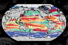
Now Sonnewald and her colleagues at MIT have developed an unsupervised machine-learning technique that automatically combs through a highly complicated set of global ocean data to find commonalities between marine locations, based on their ratios and interactions between multiple phytoplankton species. With their technique, the researchers found that the ocean can be split into over 100 types of “provinces” that are distinct in their ecological makeup. Any given location in the ocean would conceivably fit into one of these 100 ecological provinces.
The researchers then looked for similarities between these 100 provinces, ultimately grouping them into 12 more general categories. From these “megaprovinces,” they were able to see that, while some had the same total amount of life within a region, they had very different community structures, or balances of animal and plant species. Sonnewald says capturing these ecological subtleties is essential to tracking the ocean’s health and productivity.
“Ecosystems are changing with climate change, and the community structure needs to be monitored to understand knock on effects on fisheries and the ocean’s capacity to draw down carbon dioxide,” Sonnewald says. “We can't fully understand these vital dynamics with conventional methods, that to date don’t include the ecology that’s there. But our method, combined with satellite data and other tools, could offer important progress.”
Sonnewald, who is now an associate research scholar at Princeton University and a visitor at the University of Washington, has reported the results today in the journal Science Advances. Her coauthors at MIT are Senior Research Scientist Stephanie Dutkiewitz, Principal Research Engineer Christopher Hill, and Research Scientist Gael Forget.
Link to article: